Pick the name of the highlighted marker.
Keep practicing

Now make your own
Upload your prep book, slides or notes, or just tell Bo what you want to learn. You do not need a document to start.
About this diagram
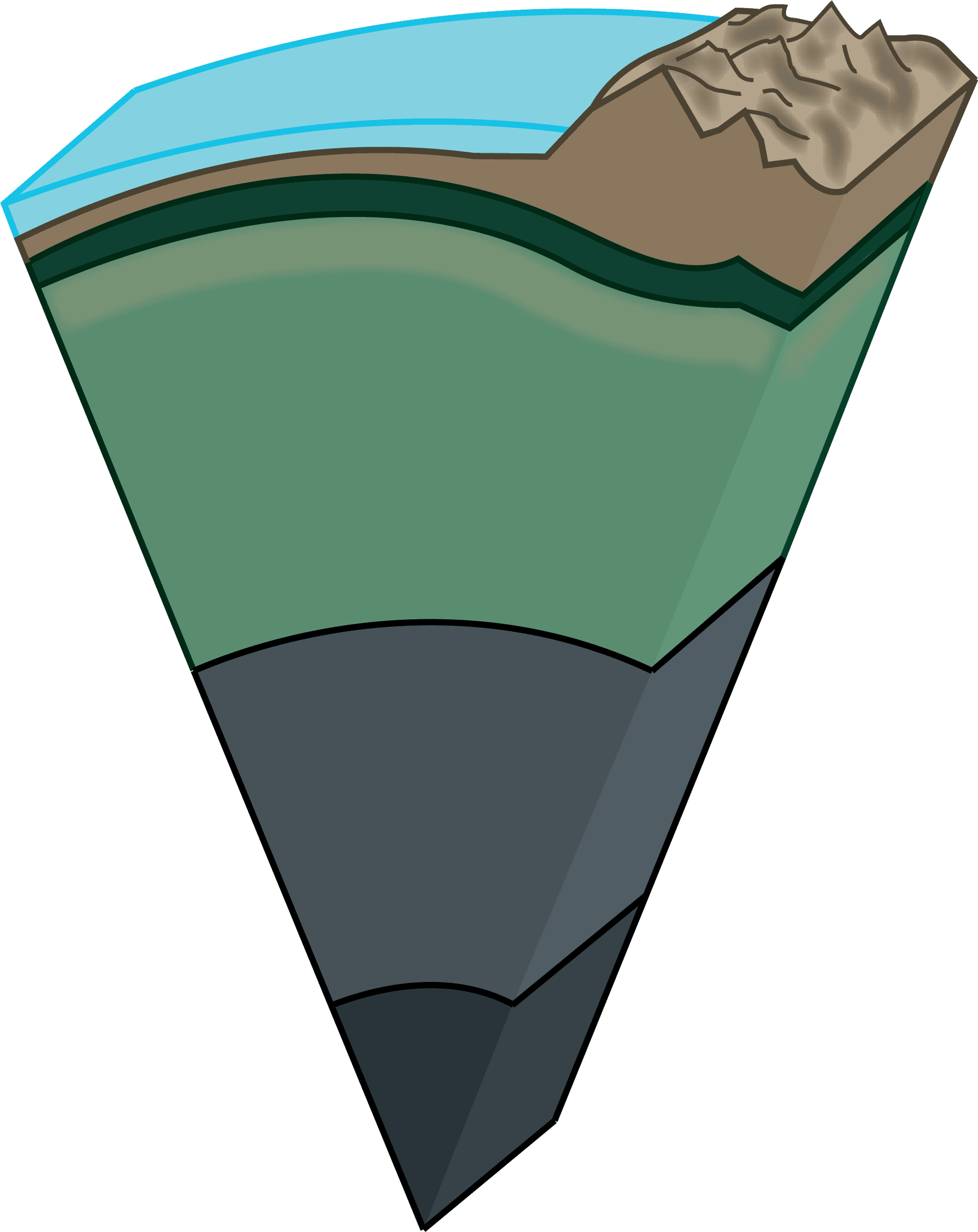
Tap a marker on the cutaway and pick the layer it belongs to. There are seven markers, from the continental crust at the surface down to the inner core at the center. The blue slab on top is ocean water, not a layer, and the lighter shaded face on the right is just the side of the wedge, drawn in the same layers.
All 7 labels on this diagram
Every marker on the figure is listed below with what it does. Answers stay collapsed until you open them, so you can quiz yourself as you scroll.
1.Continental crust
The thick brown block on the right, the crust that makes up the land. It is lighter than oceanic crust and made mostly of granite-like rock. It is much thicker than oceanic crust, roughly 30 to 40 km on average and far more under big mountain ranges, and parts of it are billions of years old.
2.Oceanic crust
The thin brown layer under the ocean. It is only about 5 to 10 km thick and made of dark, dense basalt. None of it is older than roughly 200 million years, because it keeps being pushed back down into the mantle at subduction zones.
3.Lithospheric mantle
The dark green band under the crust, the cool, rigid top of the mantle. It is welded to the crust above it, and the two together are the lithosphere, which averages roughly 100 km thick and is broken into the tectonic plates.
4.Asthenosphere
The lighter band just below the lithosphere. It is still solid rock, but hot and weak enough to flow very slowly, which is what lets the rigid plates above it move. It has no sharp edge, so the drawing shades it softly, and it reaches down a few hundred km.
5.Mantle
The big green region and by far the largest layer. It runs from the base of the crust down to about 2,890 km and holds roughly 84 percent of Earth's volume. It is solid silicate rock rich in iron and magnesium that churns slowly over millions of years, and the lithospheric mantle and asthenosphere are its uppermost parts.
6.Outer core
The gray layer from about 2,890 km to about 5,150 km down, and the only layer that is liquid. It is molten iron and nickel with some lighter elements mixed in, and its slow circulation is what generates Earth's magnetic field.
7.Inner core
The dark point of the wedge at the center, a solid ball of mostly iron and nickel with a radius of roughly 1,200 km. It is extremely hot, but the pressure at the center is so great that the metal stays solid anyway.
Four layers, five or seven: why the counts differ
Worksheets disagree on how many layers the Earth has because they slice it by different rules, and none of them is wrong.
By composition, meaning what the rock is made of, there are three layers: the crust, the mantle and the core. Splitting the core into a liquid outer part and a solid inner part, a difference of state, gives the four layers most school courses use: crust, mantle, outer core and inner core.
By strength, meaning how the material behaves, there are five: the rigid lithosphere (the crust plus the top of the mantle), the weak asthenosphere, the rest of the mantle, the liquid outer core and the solid inner core. This drawing uses seven labels because it also separates continental from oceanic crust and shows the lithospheric mantle and asthenosphere inside the mantle.
If your course counts differently, learn your course's list for the test. It is the same planet cut in a different place. A handy way to keep them apart: composition tells you what a layer is made of, and strength tells you how it moves.
Reading this figure: a wedge, with the crust drawn too thick
The picture is a wedge cut out of the planet, so the point at the bottom is the center of the Earth and the curved top is the surface. Going down from the surface, the layers run in this order: crust, lithospheric mantle, asthenosphere, mantle, outer core, inner core.
Two things are exaggerated so you can see them. The crust is drawn as a visible brown band, but it is about one percent of the distance to the center or less, from roughly 5 km under the ocean to a few tens of kilometers under the continents, out of about 6,370. The ocean on top is not a layer of the Earth at all, and its depth is not to scale either.
For rough depths, remember these. The lithosphere is about 100 km thick. The mantle ends at about 2,890 km. The outer core ends at about 5,150 km. The center is at about 6,370 km. Sources differ by a few kilometers, so treat each as approximate, and note that the boundary between lithosphere and asthenosphere is gradual rather than a line.
How StudyPDF turns your own diagrams into labeling practice
One figure with seven markers will get you through a quiz. A test in your class will use the diagram from your own textbook, drawn in a different style, with the terms your teacher expects.
StudyPDF works from your material instead. Upload the chapter, the lecture slides or your worksheet, and Bo, the study agent, builds practice from those exact pages, including the figures in them. Every explanation cites where the answer came from, so you can go straight back to the page.
You do not need a file to start. Name a topic instead, for example plate tectonics or how seismic waves reveal the core, and Bo sets up practice on it. Starting is free.
Written by the StudyPDF team. Last updated August 19, 2026.
Good to know
What are the layers of the Earth, in order?
From the surface down: the crust, the mantle, the outer core and the inner core. Inside the mantle, the cool rigid top (which joins the crust to form the lithosphere) sits above the weaker asthenosphere. Approximate depths: the crust is only about 5 to 70 km thick depending on where you stand, the mantle ends at about 2,890 km, the outer core at about 5,150 km and the center is about 6,370 km down.
Which layers of the Earth are solid and which are liquid?
The crust and the inner core are solid. The mantle is solid rock too, but over millions of years it flows slowly. The outer core is the only liquid layer. We know because earthquake waves that shear the rock, called S waves, cannot travel through liquid, and they do not pass through the outer core.
What is the difference between the crust and the lithosphere?
The crust is the outermost layer by composition, the rock you can walk on. The lithosphere is a layer by strength: the crust plus the rigid uppermost mantle beneath it, roughly 100 km thick in total. The tectonic plates are pieces of the lithosphere, and they move on the weaker asthenosphere below.
Is this free, and can I print it as a worksheet?
Yes. All seven markers, your score and the explanation for every layer are free to play in your browser. The printable label list needs a free StudyPDF account.